Increased free API limit, satellite acquisition plan viewer improvements and more!
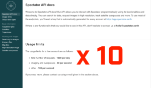
It’s difficult to prototype new ideas without the right tools that would allow us to focus only on the most important things. For this reason, we’ve decided to increase the daily limit on our API usage. We hope this will make it even easier for you to create and share awesome knowledge built based on satellite data!
New features and improvements
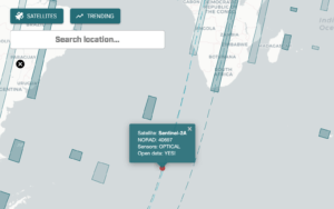
In the previous version, the acquisition plan viewer was quite separated from the rest of the app. It was difficult to browse through planned acquisitions and then create observation to view the data or turn on the notifications. We’ve fixed it! You can now create observations for browsing data and getting notifications, directly from the acquisition plan viewer. Full list of features and improvements
- create observations directly from acquisition plan viewer with notifications turned on by default
- control which notifications to display from the notifications list
- display trending locations and satellite animation directly on the acquisition plan viewer
- display overpass countdown for overpasses
- daily usage limit for free API increased 10x
- adding tile caching for 10x faster image preview response
Bugfixes
We’ve also fixed some of the issues you could have problems with. Here’s the list:
- set default satellites on create observation view
- create an observation from search when satellites loading
- allow to always display satellite imagery at full resolution
- allow downloading screenshot image when multiple images loaded
- display pending imagery chip only when filters are not changed
Let us know what you think! Go to the APP!