Frequently Asked Questions
How to order a high-resolution satellite imagery?
When using the app, in the bottom-left corner of the map you have a button that allows you to enter the HD imagery picker. The button activates when:
- you’re logged in
- you zoomed in on an area of interest (e.g. it will not activate when viewing very large areas)
This is where you can find the button:

The purchase is only possible if there is high-resolution satellite imagery available for your area of interest. The picker allows you to browse and purchase archive high-resolution imagery by defining three main parameters – imagery resolution, date and order size.
Imagery resolution and date
You can choose from available satellite imagery using the resolution options switch and date options switch(see image below). Before buying, it’s worth having a look at differences in satellite imagery resolution.
Order area
The exact area that you’re ordering will be defined by the square box in the middle. Just pan and zoom the map in order to set the box over the area for which you would like to purchase imagery. The red area underneath the box defines the extent of the currently chosen satellite imagery(based on resolution and date options). You won’t be able to buy an area outside of the currently chosen satellite acquisition. You can change the size of the box using area size options(see the image below).
Preview
When using a high-resolution imagery picker the mini-map in the top-right corner displays a low-resolution preview of the currently chosen imagery. This is to help you when trying to avoid cloudy areas and as an overview of the lighting conditions on the image that you consider buying.

What are the differences in satellite-imagery spatial resolutions?
For a quick answer please use the slider below to see a difference between a 10m resolution(left) and 50cm resolution(right) satellite imagery of Main Square in Krakow, Poland.


Now the long answer. The spatial resolution of satellite imagery describes the size of image pixels in the physical world. It’s a value that you can use as a reference when thinking about what type of objects you’ll be able to see on the image. For example, 10m resolution imagery will only allow you to observe large scale events(e.g. wildfires) or objects(e.g. airports). When looking for smaller objects or a more detailed view, you’ll need high-resolution imagery.
Let’s take a car as an example. The average size of a car is around 4.5m x 2m. That’s 9m². You won’t see a car on a 10m resolution image, as the area of one pixel is 10m x 10m = 100m². Anything that will fall in that one pixel will be a single colour blob. If you take 50cm imagery, one pixel will be 0.5m x 0.5m = 0.25m². Therefore, a 9m² car will have 36 pixels which should be enough to describe a car’s shape, but it’s not like you’re going to read the license plates 😉
How can I use the high-resolution imagery from app.spectator.earth?
You are allowed to visualise SPOT and Pleiades data in the app. You are not allowed to download, nor to use it as a standalone product. More information on Airbus license can be found here.
Can I see some high-resolution data samples?
Can I access raw spectral bands or georeferencing information for commercial data?
No.
At the moment we provide commercial data as a layer on the map. We don’t provide access to raw data products including spectral bands and georeferencing.
Where can I find all my purchased imagery?

Can I see live view from the satellites?
No.
The satellite tracking in the app is performed in real-time however, the imagery acquired by the satellites is usually significantly delayed(a very rough estimation is “a couple of hours”). Moreover, not all satellites acquire images with the same frequency, so always pay attention to the imagery date displayed in the app.
Can I request an image at specific date and time?
Unless the time and date match the images available in the archive, the answer is no.
Satellites acquire images only in specific time windows when flying over a location. Therefore if you, for example, look for an image of London from yesterday at 12:43 pm, you probably won’t be able to get one. You may get closer to desired date and time when ordering new satellite acquisitions, however, at the moment we don’t offer satellite tasking.
How to check satellite overpasses in my area?
You can check the time and location of the chosen satellite’s overpass through acquisition plan viewer. This is how you can check if a chosen satellite will be in the area of your interest on a given day.
Can I change the language?
Currently, you can only choose between Polish and English language from your profile in the app. More languages will be systematically added in the future.
How can I display satellite image?
Once you created your observation, you can display an image by clicking on an element in the images list. Once clicked, the image should start loading on the map.


How far back does the archive with satellite images go?
At the moment we serve data for Sentinel-2, SPOT, Pleiades and Pleiades Neo. Depending on which one you choose the data can go as far back as 2015.
Which satellite images can I display?
At the moment we provide data from Copernicus Sentinel-2, Airbus SPOT, Pleiades, and Pleiades Neo. We will be systematically adding more data from other satellites.
How to switch between different satellite images added to the map?
You can switch between loaded images by using the layer controller available from the top-left corner of the map. To toggle image visibility click the eye icon as presented below.


What is satellite remote sensing used for?
Satellite remote sensing is used for monitoring and detecting changes for any given area around the globe. It can be leveraged for personal use but also to keep an eye on the increasingly frequent droughts, floods, melting of glaciers, wildfires, and deforestation.
How to track a satellite?
In our platform, by default, we display satellite orbits of Sentinel-2A, Sentinel-2B and Landsat-8. You can display the trajectories of other Earth Observation satellites from the satellite menu available in the layer controller(see the image below).
The menu displays all satellites available to track. In the example below, we want to add Landsat-9 to the map, and we do it by just clicking on the satellite.


Are satellite images free of charge?
There is plenty of satellite data freely available, such as Copernicus Sentinels or Landsat, some of which you can access through Spectator. Usually, the higher-resolution data, such as Pleiades/SPOT, requires payment.
How do I delete observations?
You can delete observations from the observations list by selecting them in your workspace. After selecting an observation, you can click “delete selected”. You can also delete a whole observations list, by clicking on the “trash” icon in the top right corner.


How to go through older images?
You can use the image filters available after clicking “more…” under the initial image list in the observation. You can either use presets or the “custom” button which opens a calendar to define a precise time period. You can go back and forth in months and years through arrows on the top right and left corners, or you can select the date by clicking visible at the top, present month, then a year, and so on.


Is there a preview of the high-resolution image?
There is a small preview that is only shown in the top-right corner in a form of a mini-map.

How to select a specific area?
To select a specific area, you can type it in the search engine or you can pass the Lat-Long and search it through the coordinates. Alternatively, you can also define the area by clicking the create observation button at the bottom of the map.


What are the best locations to monitor with satellite imagery?
Satellite imagery is a valuable resource for collecting, processing, and analyzing information. However, satellites don’t allow us to view everything around the world all at once. Instead, we must choose our areas of interest and select specific places that we want to monitor. And for that reason, we created a list of the most interesting observations, with some of the best locations recently to follow with satellite imagery.
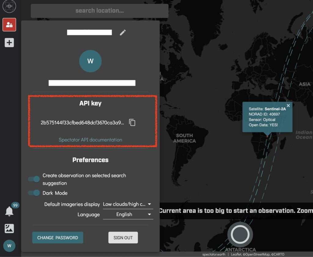
Where can I find my API key?
If you would like to interact with the data programmatically, you can do it through our API. The API key is generated for every new account in https://app.spectator.earth and can be found in the account panel(see image below).
For more information on the API, go to https://api.spectator.earth.
How to add images from your observations to QGIS?
Using our platform you can easily add images from your satellite observations to QGIS. For a step-by-step tutorial on how to display your observations follow our guide – view the guide!